
Tübingen topographic map
Interactive map
Click on the map to display elevation.
About this map
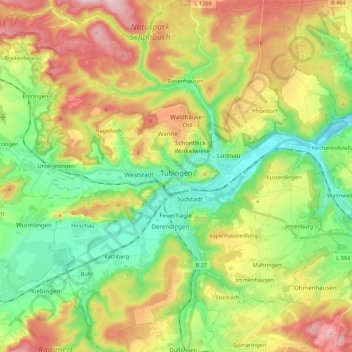
Name: Tübingen topographic map, elevation, terrain.
Location: Tübingen, Landkreis Tübingen, Baden-Württemberg, Germany (48.45058 8.96452 48.59371 9.13107)
Average elevation: 413 m
Minimum elevation: 301 m
Maximum elevation: 580 m
Other topographic maps
Click on a map to view its topography, its elevation and its terrain.
Rottenburg am Neckar
Germany > Baden-Württemberg > Landkreis Tübingen
Rottenburg am Neckar, Verwaltungsgemeinschaft Rottenburg am Neckar, Landkreis Tübingen, Baden-Württemberg, 72108, Germany
Average elevation: 440 m