
Jockgrim topographic map
Interactive map
Click on the map to display elevation.
About this map
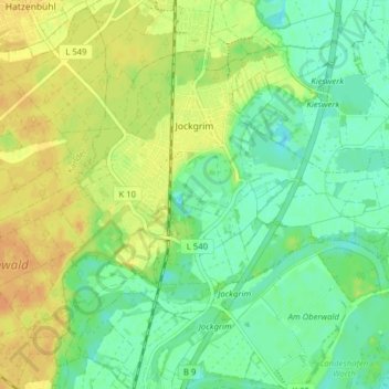
Name: Jockgrim topographic map, elevation, terrain.
Average elevation: 109 m
Minimum elevation: 95 m
Maximum elevation: 124 m
Other topographic maps
Click on a map to view its topography, its elevation and its terrain.
Bellheim
Germany > Rhineland-Palatinate > Landkreis Germersheim
Bellheim, Landkreis Germersheim, Rhineland-Palatinate, 76756, Germany
Average elevation: 119 m
Rülzheim
Germany > Rhineland-Palatinate > Landkreis Germersheim
Rülzheim, Landkreis Germersheim, Rhineland-Palatinate, 76761, Germany
Average elevation: 115 m
Lingenfeld
Germany > Rhineland-Palatinate > Landkreis Germersheim
Lingenfeld, Landkreis Germersheim, Rhineland-Palatinate, 67360, Germany
Average elevation: 110 m
Germersheim
Germany > Rhineland-Palatinate > Landkreis Germersheim
Germersheim, Landkreis Germersheim, Rhineland-Palatinate, 76726, Germany
Average elevation: 104 m