
Wales topographic map
Interactive map
Click on the map to display elevation.
About this map
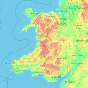
Name: Wales topographic map, elevation, terrain.
Location: Wales, United Kingdom (51.22903 -5.80773 53.63500 -2.64986)
Average elevation: 99 m
Minimum elevation: 0 m
Maximum elevation: 1,001 m
Much of Wales' diverse landscape is mountainous, particularly in the north and central regions. The mountains were shaped during the last ice age, the Devensian glaciation. The highest mountains in Wales are in Snowdonia (Eryri), of which five are over 1,000 m (3,300 ft). The highest of these is Snowdon (Yr Wyddfa), at 1,085 m (3,560 ft). The 14 Welsh mountains, or 15 if including Carnedd Gwenllian – often discounted because of its low topographic prominence – over 3,000 feet (910 metres) high are known collectively as the Welsh 3000s and are located in a small area in the north-west. The highest outside the 3000s is Aran Fawddwy, at 905 metres (2,969 feet), in the south of Snowdonia. The Brecon Beacons (Bannau Brycheiniog) are in the south (highest point Pen y Fan, at 886 metres (2,907 feet)), and are joined by the Cambrian Mountains in Mid Wales (highest point Pumlumon, at 752 metres (2,467 feet)).
Other topographic maps
Click on a map to view its topography, its elevation and its terrain.
London
United Kingdom > England > London
London, Greater London, England, SW1A 2DX, United Kingdom
Average elevation: 42 m
Cardiff
United Kingdom > Wales > Cardiff
Cardiff, Wales, CF10 2AF, United Kingdom
Average elevation: 55 m
London
London, Greater London, England, United Kingdom
Average elevation: 66 m
Sheffield
Sheffield, South Yorkshire, England, United Kingdom
Average elevation: 168 m
Cambridgeshire
Cambridgeshire, Cambridgeshire and Peterborough, England, United Kingdom
Average elevation: 32 m
Bristol
United Kingdom > England > City of Bristol
Bristol, City of Bristol, West of England, England, United Kingdom
Average elevation: 55 m
Edinburgh
United Kingdom > Scotland > Edinburgh
Edinburgh, City of Edinburgh, Scotland, EH1 3EG, United Kingdom
Average elevation: 104 m
Liverpool
Liverpool, Liverpool City Region, England, United Kingdom
Average elevation: 26 m
Newcastle upon Tyne
Newcastle upon Tyne, North of Tyne, England, United Kingdom
Average elevation: 57 m
Coventry
Coventry, West Midlands Combined Authority, England, United Kingdom
Average elevation: 99 m
City of London
United Kingdom > England > City of London > City of London
City of London, England, EC2V 5AE, United Kingdom
Average elevation: 42 m
Somerset
Somerset, South West England, England, United Kingdom
Average elevation: 87 m
Fort William
United Kingdom > Scotland > Highland
Fort William, Highland, Scotland, PH33 6AQ, United Kingdom
Average elevation: 122 m
St Albans
United Kingdom > England > Hertfordshire > St Albans
St Albans, Hertfordshire, East of England, England, United Kingdom
Average elevation: 100 m
Nottingham
United Kingdom > England > Nottinghamshire
Nottingham, England, United Kingdom
Average elevation: 56 m
Buxton
United Kingdom > England > Derbyshire > High Peak
Buxton, High Peak, Derbyshire, England, United Kingdom
Average elevation: 334 m
South East England
South East England, England, United Kingdom
Average elevation: 69 m
Warminster
United Kingdom > England > Wiltshire
Warminster, Wiltshire, England, United Kingdom
Average elevation: 143 m
Wirral
Wirral, Liverpool City Region, England, United Kingdom
Average elevation: 21 m
Skye
United Kingdom > Scotland > Highland
Skye, Highland, Scotland, United Kingdom
Average elevation: 63 m
Greater Manchester
Greater Manchester, England, United Kingdom
Average elevation: 141 m
Aberystwyth
United Kingdom > Wales > Ceredigion
Aberystwyth, Ceredigion, Wales, SY23 1LH, United Kingdom
Average elevation: 39 m
Bath
United Kingdom > England > Bath and North East Somerset
Bath, Bath and North East Somerset, West of England, England, United Kingdom
Average elevation: 100 m
Swansea
United Kingdom > Wales > Swansea
Swansea, Wales, SA1 3BN, United Kingdom
Average elevation: 73 m
Cambridge
United Kingdom > England > Cambridge
Cambridge, Cambridgeshire, East of England, England, United Kingdom
Average elevation: 18 m
Bradford
Bradford, West Yorkshire, England, United Kingdom
Average elevation: 175 m
Guildford
United Kingdom > England > Surrey
Guildford, Surrey, England, United Kingdom
Average elevation: 74 m
Enborne Row
United Kingdom > England > West Berkshire
Enborne Row, West Berkshire, England, RG20 0PR, United Kingdom
Average elevation: 112 m
South Pool
United Kingdom > England > Devon > South Hams
South Pool, South Hams, Devon, England, United Kingdom
Average elevation: 38 m
Stibb Cross
United Kingdom > England > Devon > Torridge District
Stibb Cross, Langtree, Torridge District, Devon, England, EX38 8HZ, United Kingdom
Average elevation: 157 m
Brent Eleigh
United Kingdom > England > Suffolk > Babergh
Brent Eleigh, Babergh, Suffolk, England, United Kingdom
Average elevation: 64 m
Westridge Green
United Kingdom > England > West Berkshire > Aldworth
Westridge Green, Aldworth, West Berkshire, England, RG8 9RF, United Kingdom
Average elevation: 145 m
North Norfolk
United Kingdom > England > Norfolk
North Norfolk, Norfolk, England, United Kingdom
Average elevation: 26 m
Hampshire
Hampshire, South East, England, United Kingdom
Average elevation: 73 m