
Weston topographic map
Interactive map
Click on the map to display elevation.
About this map
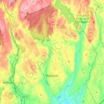
Name: Weston topographic map, elevation, terrain.
Average elevation: 98 m
Minimum elevation: 4 m
Maximum elevation: 206 m
Other topographic maps
Click on a map to view its topography, its elevation and its terrain.
Harborview
United States > Connecticut > Western Connecticut COG > Norwalk
Harborview, Norwalk, Western Connecticut COG, Connecticut, 06855, United States
Average elevation: 6 m
Brookfield
United States > Connecticut > Western Connecticut COG
Brookfield, Western Connecticut COG, Connecticut, 06804, United States
Average elevation: 139 m
Cedar Heights
United States > Connecticut > Western Connecticut COG > Danbury
Cedar Heights, Danbury, Western Connecticut COG, Connecticut, 06804, United States
Average elevation: 145 m
Bethel
United States > Connecticut > Western Connecticut COG > Bethel
Bethel, Western Connecticut COG, Connecticut, 06801, United States
Average elevation: 144 m
High Ridge
United States > Connecticut > Western Connecticut COG > Stamford
High Ridge, Stamford, Western Connecticut COG, Connecticut, 06903, United States
Average elevation: 119 m