
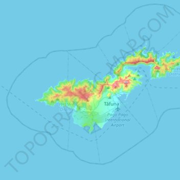
Tutuila topographic map
Interactive map
Click on the map to display elevation.
About this map
Name: Tutuila topographic map, elevation, terrain.
Average elevation: 20 m
Minimum elevation: -1 m
Maximum elevation: 589 m
Tutuila is a fairly small and narrow island, measuring roughly 33 km (21 mi) across and little more than 3 mi (4.8 km) from north to south at its widest point. The area of this volcanic island of early Pliocene age is 142.3 km2 (54.9 sq mi) with a shore line of 101.3 km (62.9 mi). The hill range which runs from west to east is rugged and winding with the northern coast line having steep cliffs and unusual coast line. However, the southern part of the island has flatter terrain. Good beaches are located at many places along the coast. It has a wet tropical climate. The highest point in the Tutuila island is the Matafao Peak which is at an elevation of 653 meters (2,142 ft), which is highest peak in the island. There is trail opposite to the Mount ʻAlava peak (483 km (300 mi)) which dominates the northern part of the island. This 9.7 km (6.0 mi) trail is approached by a metal stairway from the southern end which goes right up to the peak. Trekking along the ridge through the rain forests without any additional support system, the scenic beauty of the South Pacific Ocean provides a delightful sight.