
Eureka Springs topographic map
Interactive map
Click on the map to display elevation.
About this map
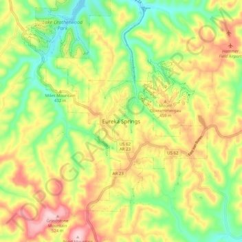
Name: Eureka Springs topographic map, elevation, terrain.
Average elevation: 417 m
Minimum elevation: 311 m
Maximum elevation: 541 m
It is a tourist destination for its unique character as a Victorian resort village. The city has steep winding streets filled with Victorian-style cottages and manors. The historic commercial downtown of the city has an extensive streetscape of well-preserved Victorian buildings. The buildings are primarily constructed of local stone, built along streets that curve around the hills and rise and fall with the topography in a five-mile long loop. Some buildings have street-level entrances on more than one floor and other such oddities: the Basin Park Hotel has its front entrances on the floor below first, and a ground-level emergency exit in the back of the building on the fifth floor. The streets wind around the town, with few intersecting at right angles. There are no traffic lights.