
Lamayuru topographic map
Interactive map
Click on the map to display elevation.
About this map
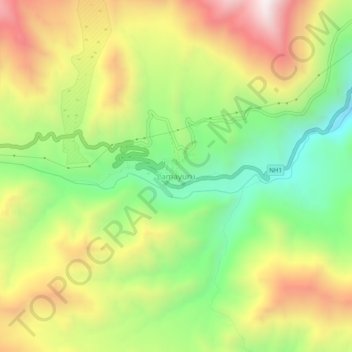
Name: Lamayuru topographic map, elevation, terrain.
Location: Lamayuru, Khalsi tehsil, Leh district, Ladakh, India (34.26271 76.75396 34.30271 76.79396)
Average elevation: 3,691 m
Minimum elevation: 3,242 m
Maximum elevation: 4,228 m
Other topographic maps
Click on a map to view its topography, its elevation and its terrain.
Ursi
India > Ladakh > Khalsi tehsil
Ursi, Khalsi tehsil, Leh District, Ladakh, India
Average elevation: 3,941 m
Lingshed
India > Ladakh > Khalsi tehsil
Lingshed, Khalsi tehsil, Leh District, Ladakh, India
Average elevation: 4,209 m
Debring
India > Ladakh > Khalsi tehsil
Debring, Khalsi tehsil, Leh District, Ladakh, India
Average elevation: 4,380 m
Yulchung
India > Ladakh > Khalsi tehsil
Yulchung, Khalsi tehsil, Leh district, Ladakh, India
Average elevation: 4,224 m