
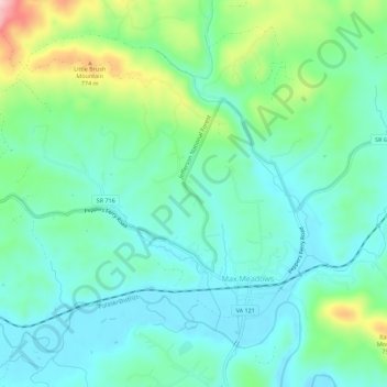
Max Meadows topographic map
Interactive map
Click on the map to display elevation.
About this map
Name: Max Meadows topographic map, elevation, terrain.
Location: Max Meadows, Wythe County, Virginia, United States (36.96319 -80.99734 36.99965 -80.94156)
Average elevation: 662 m
Minimum elevation: 606 m
Maximum elevation: 830 m
Other topographic maps
Click on a map to view its topography, its elevation and its terrain.
Austinville
United States > Virginia > Wythe County
Austinville, Wythe County, Virginia, 24312, United States
Average elevation: 645 m
Ivanhoe
United States > Virginia > Wythe County
Ivanhoe, Wythe County, Virginia, 24350, United States
Average elevation: 643 m
Cripple Creek
United States > Virginia > Wythe County > Speedwell
Cripple Creek, Speedwell, Wythe County, Virginia, 24374, United States
Average elevation: 733 m
Wytheville
United States > Virginia > Wythe County
Wytheville, Wythe County, Virginia, 24382, United States
Average elevation: 720 m
Barren Springs
United States > Virginia > Wythe County
Barren Springs, Wythe County, Virginia, 24313, United States
Average elevation: 642 m
Stones Mill
United States > Virginia > Wythe County > Wytheville > Stones Mill
Stones Mill, Wytheville, Wythe County, Virginia, 24382, United States
Average elevation: 710 m