
Indus topographic map
Interactive map
Click on the map to display elevation.
About this map
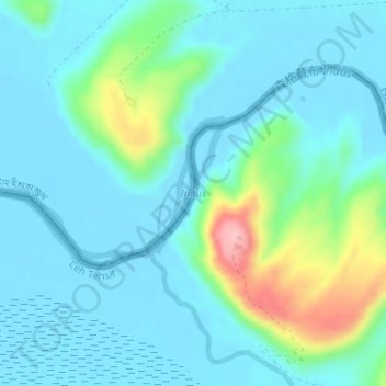
Name: Indus topographic map, elevation, terrain.
Location: Indus, Leh Tehsil, Leh district, Ladakh, India (32.96090 79.21348 32.97171 79.22687)
Average elevation: 4,192 m
Minimum elevation: 4,161 m
Maximum elevation: 4,323 m
In the uppermost, highest part of the Indus River basin there are relatively few genera and species: Diptychus, Ptychobarbus, Schizopyge, Schizopygopsis and Schizothorax snowtrout, Triplophysa loaches, and the catfish Glyptosternon reticulatum. Going downstream these are soon joined by the golden mahseer Tor putitora (alternatively T. macrolepis, although it often is regarded as a synonym of T. putitora) and Schistura loaches. Downriver from around Thakot, Tarbela, the Kabul–Indus river confluence, Attock Khurd and Peshawar the diversity rises strongly, including many cyprinids (Amblypharyngodon, Aspidoparia, Barilius, Chela, Cirrhinus, Crossocheilus, Cyprinion, Danio, Devario, Esomus, Garra, Labeo, Naziritor, Osteobrama, Pethia, Puntius, Rasbora, Salmophasia, Securicula and Systomus), true loaches (Botia and Lepidocephalus), stone loaches (Acanthocobitis and Nemacheilus), ailiid catfish (Clupisoma), bagridae catfish (Batasio, Mystus, Rita and Sperata), airsac catfish (Heteropneustes), schilbid catfish (Eutropiichthys), silurid catfish (Ompok and Wallago), sisorid catfish (Bagarius, Gagata, Glyptothorax and Sisor), gouramis (Trichogaster), nandid leaffish (Nandus), snakeheads (Channa), spiny eel (Macrognathus and Mastacembelus), knifefish (Notopterus), glassfish (Chanda and Parambassis), clupeids (Gudusia), needlefish (Xenentodon) and gobies (Glossogobius), as well as a few introduced species. As the altitude further declines the Indus basin becomes overall quite slow-flowing as it passes through the Punjab Plain. Major carp become common, and chameleonfish (Badis), mullet (Sicamugil) and swamp eel (Monopterus) appear. In some upland lakes and tributaries of the Punjab region snowtrout and mahseer are still common, but once the Indus basin reaches its lower plain the former group is entirely absent and the latter are rare. Many of the species of the middle sections of the Indus basin are also present in the lower. Notable examples of genera that are present in the lower plain but generally not elsewhere in the Indus River basin are the Aphanius pupfish, Aplocheilus killifish, palla fish (Tenualosa ilisha), catla (Labeo catla), rohu (Labeo rohita) and Cirrhinus mrigala. The lowermost part of the river and its delta are home to freshwater fish, but also a number of brackish and marine species. This includes pomfret and prawns. The large delta has been recognized by conservationists as an important ecological region. Here, the river turns into many marshes, streams and creeks and meets the sea at shallow levels.
Other topographic maps
Click on a map to view its topography, its elevation and its terrain.
Hemis National Park
India > Ladakh > Leh Tehsil
Hemis National Park, Leh Tehsil, Leh District, Ladakh, India
Average elevation: 4,694 m
Mud volcano area
India > Ladakh > Leh Tehsil
Mud volcano area, Leh Tehsil, Leh District, Ladakh, India
Average elevation: 4,544 m
Sakti Tukchu
India > Ladakh > Leh Tehsil
Sakti Tukchu, Leh Tehsil, Leh District, Ladakh, India
Average elevation: 3,965 m
Tanglang
India > Ladakh > Leh Tehsil
Tanglang, Leh Tehsil, Leh District, Ladakh, India
Average elevation: 5,462 m
Leh
India > Ladakh > Leh Tehsil
Leh, Leh Tehsil, Leh District, Ladakh, India
Average elevation: 3,653 m
Kang Yatse 4 North
India > Ladakh > Leh Tehsil
Kang Yatse 4 North, Leh Tehsil, Leh district, Ladakh, India
Average elevation: 5,759 m
Markha
India > Ladakh > Leh Tehsil
Markha, Leh Tehsil, Leh district, Ladakh, India
Average elevation: 4,093 m
Nimo
India > Ladakh > Leh Tehsil
Nimo, Leh Tehsil, Leh district, Ladakh, India
Average elevation: 3,282 m
Kangju Kangri
India > Ladakh > Leh Tehsil
Kangju Kangri, Leh Tehsil, Leh district, Ladakh, India
Average elevation: 6,190 m
Phyang
India > Ladakh > Leh Tehsil
Phyang, Leh Tehsil, Leh district, Ladakh, 194101, India
Average elevation: 3,742 m
Spituk
India > Ladakh > Leh Tehsil
Spituk, Leh Tehsil, Leh district, Ladakh, India
Average elevation: 3,253 m
Hanle
India > Ladakh > Leh Tehsil
Hanle, Leh Tehsil, Leh district, Ladakh, India
Average elevation: 4,287 m
Phe
India > Ladakh > Leh Tehsil
Phe, Leh Tehsil, Leh district, Ladakh, India
Average elevation: 4,841 m
Hemis
India > Ladakh > Leh Tehsil
Hemis, Leh Tehsil, Leh district, Ladakh, India
Average elevation: 5,218 m
Thiksey
India > Ladakh > Leh Tehsil > Thiksey
Thiksey, Leh Tehsil, Leh district, Ladakh, 194201, India
Average elevation: 3,304 m
Alchi
India > Ladakh > Leh Tehsil
Alchi, Leh Tehsil, Leh district, Ladakh, India
Average elevation: 4,285 m