
Kenai Fjords National Park topographic map
Interactive map
Click on the map to display elevation.
About this map
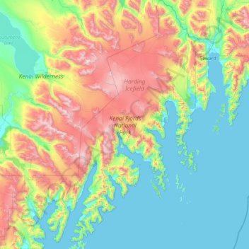
Name: Kenai Fjords National Park topographic map, elevation, terrain.
Average elevation: 518 m
Minimum elevation: -2 m
Maximum elevation: 1,972 m
The park's landscape has been shaped by plate tectonics, with the Pacific Plate subducting beneath the North American Plate. The process has lowered the elevation of the Kenai Mountains, gradually pulling glacial features down into the sea, which is at the same time rising. The floors of the fjords can be from 600 to 1,000 feet (180 to 300 m) below the present sea level. The motion of the North Pacific Plate has accreted a variety of terranes against the shoreline, so that the coastal region is a mixture of rocks that originated elsewhere, together with local igneous rock. Predominant rock types include shale and graywacke, with greenstone, tuff and chert.
Other topographic maps
Click on a map to view its topography, its elevation and its terrain.
Homer
United States > Alaska > Kenai Peninsula > Homer
Homer, Kenai Peninsula, Alaska, United States
Average elevation: 106 m
Seward
United States > Alaska > Kenai Peninsula
Seward, Kenai Peninsula, Alaska, 99664, United States
Average elevation: 260 m
Seward
United States > Alaska > Kenai Peninsula > Seward
Seward, Kenai Peninsula, Alaska, United States
Average elevation: 328 m
Sterling
United States > Alaska > Kenai Peninsula
Sterling, Kenai Peninsula, Alaska, 99672, United States
Average elevation: 78 m
Homer
United States > Alaska > Kenai Peninsula
Homer, Kenai Peninsula, Alaska, United States
Average elevation: 104 m
Resurrection Bay
United States > Alaska > Kenai Peninsula
Resurrection Bay, Kenai Peninsula, Alaska, United States
Average elevation: 3 m
Moose Pass
United States > Alaska > Kenai Peninsula
Moose Pass, Kenai Peninsula, Alaska, 99631, United States
Average elevation: 643 m
Marathon Mountain
United States > Alaska > Kenai Peninsula
Marathon Mountain, Kenai Peninsula, Alaska, United States
Average elevation: 862 m
Kenai
United States > Alaska > Kenai Peninsula
Kenai, Kenai Peninsula, Alaska, United States
Average elevation: 16 m
Soldotna
United States > Alaska > Kenai Peninsula
Soldotna, Kenai Peninsula, Alaska, United States
Average elevation: 45 m
Exit Glacier
United States > Alaska > Kenai Peninsula
Exit Glacier, Kenai Peninsula, Alaska, United States
Average elevation: 1,095 m