
Cambridge topographic map
Interactive map
Click on the map to display elevation.
About this map
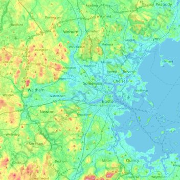
Name: Cambridge topographic map, elevation, terrain.
Average elevation: 31 m
Minimum elevation: -5 m
Maximum elevation: 152 m
Cambridge obtains water from Hobbs Brook (in Lincoln and Waltham) and Stony Brook (Waltham and Weston), as well as an emergency connection to the Massachusetts Water Resources Authority. The city owns over 1,200 acres (486 ha) of land in other towns that includes these reservoirs and portions of their watershed. Water from these reservoirs flows by gravity through an aqueduct to Fresh Pond in Cambridge. It is then treated in an adjacent plant and pumped uphill to an elevation of 176 feet (54 m) above sea level at the Payson Park Reservoir (Belmont). The water is then redistributed downhill via gravity to individual users in the city. A new water treatment plant opened in 2001.