
Lake Ouachita topographic map
Interactive map
Click on the map to display elevation.
About this map
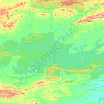
Name: Lake Ouachita topographic map, elevation, terrain.
Location: Lake Ouachita, Garland County, Arkansas, United States (34.53727 -93.57096 34.69421 -93.16588)
Average elevation: 241 m
Minimum elevation: 123 m
Maximum elevation: 585 m
Other topographic maps
Click on a map to view its topography, its elevation and its terrain.
Bear
United States > Arkansas > Garland County
Bear, Garland County, Arkansas, 71968, United States
Average elevation: 216 m
Hot Springs Village
United States > Arkansas > Garland County > Hot Springs Village
Hot Springs Village, Garland County, Arkansas, 71909, United States
Average elevation: 226 m
Garland County
United States > Arkansas > Garland County
Garland County, Arkansas, United States
Average elevation: 224 m
Hot Springs
United States > Arkansas > Garland County
Hot Springs, Garland County, Arkansas, United States
Average elevation: 172 m