
Mill Bay topographic map
Interactive map
Click on the map to display elevation.
About this map
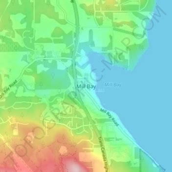
Name: Mill Bay topographic map, elevation, terrain.
Average elevation: 61 m
Minimum elevation: 0 m
Maximum elevation: 228 m
Other topographic maps
Click on a map to view its topography, its elevation and its terrain.
H500
Canada > British Columbia > Cowichan Valley Regional District > Area A (Mill Bay / Malahat)
H500, Area A (Mill Bay / Malahat), Cowichan Valley Regional District, British Columbia, V0R 2P4, Canada
Average elevation: 341 m
Bamberton Provincial Park
Canada > British Columbia > Cowichan Valley Regional District > Area A (Mill Bay / Malahat)
Bamberton Provincial Park, Sandy Beach Road, Area A (Mill Bay / Malahat), Cowichan Valley Regional District, British Columbia, V0R 2P4, Canada
Average elevation: 97 m