Geolocate

Stănești topographic map

Interactive map

Click on the map to display elevation.

About this map

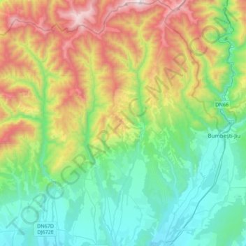
Name: Stănești topographic map, elevation, terrain.

Location: Stănești, Gorj, Romania (45.07207 23.20520 45.30991 23.30308)

Average elevation: 723 m

Minimum elevation: 217 m

Maximum elevation: 1,860 m

Other topographic maps

Click on a map to view its topography, its elevation and its terrain.

Novaci

Romania > Gorj

Novaci, Gorj, Romania

Average elevation: 1,056 m

Târgu Cărbunești

Romania > Gorj

Târgu Cărbunești, Gorj, Romania

Average elevation: 278 m

Rânca

Romania > Gorj > Rânca

Rânca, Gorj, Romania

Average elevation: 1,403 m

Bâlteni

Romania > Gorj > Bâlteni

Bâlteni, Gorj, 217060, Romania

Average elevation: 170 m

Târgu Jiu

Romania > Gorj

Târgu Jiu, Gorj, Romania

Average elevation: 233 m

Polovragi

Romania > Gorj > Polovragi

Polovragi, Gorj, 217366, Romania

Average elevation: 585 m

Bumbesti-Jiu

Romania > Gorj

Bumbesti-Jiu, Gorj, Romania

Average elevation: 774 m