
The Wells topographic map
Interactive map
Click on the map to display elevation.
About this map
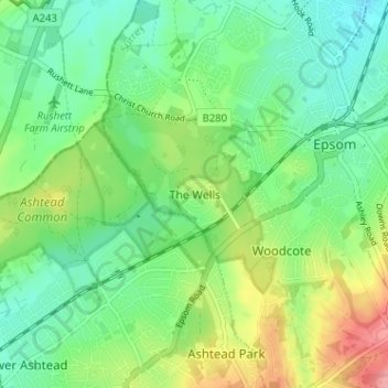
Name: The Wells topographic map, elevation, terrain.
Average elevation: 63 m
Minimum elevation: 32 m
Maximum elevation: 125 m
Other topographic maps
Click on a map to view its topography, its elevation and its terrain.
Epsom
United Kingdom > England > Surrey > Epsom and Ewell
Epsom, Epsom and Ewell, Surrey, England, KT19 8DX, United Kingdom
Average elevation: 77 m
Manor Park
United Kingdom > England > Surrey > Epsom and Ewell > Epsom
Manor Park, Epsom, Epsom and Ewell, Surrey, England, KT19 7EH, United Kingdom
Average elevation: 53 m
Grandstand Road
United Kingdom > England > Surrey > Epsom and Ewell > Epsom
Grandstand Road, Epsom, Epsom and Ewell, Surrey, England, KT18 5LQ, United Kingdom
Average elevation: 115 m
Ewell
United Kingdom > England > Surrey > Epsom and Ewell
Ewell, Epsom and Ewell, Surrey, England, KT17 1TZ, United Kingdom
Average elevation: 62 m