
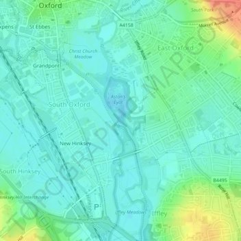
The Triangle topographic map
Interactive map
Click on the map to display elevation.
About this map
Name: The Triangle topographic map, elevation, terrain.
Average elevation: 63 m
Minimum elevation: 50 m
Maximum elevation: 101 m
Other topographic maps
Click on a map to view its topography, its elevation and its terrain.
Botley Stream
United Kingdom > England > Oxfordshire > Oxford
Botley Stream, New Botley, West Oxford, Oxford, Oxfordshire, England, OX2 0ED, United Kingdom
Average elevation: 67 m
Binsey
United Kingdom > England > Oxfordshire > Oxford
Binsey, Oxford, Oxfordshire, England, OX2 0NG, United Kingdom
Average elevation: 64 m
Oxford
United Kingdom > England > Oxfordshire > Oxford
Oxford, Oxfordshire, South East England, England, OX1 3HY, United Kingdom
Average elevation: 81 m
Marston
United Kingdom > England > Oxfordshire > Oxford
Marston, Oxford, Oxfordshire, England, OX3 0PX, United Kingdom
Average elevation: 71 m
Littlemore
United Kingdom > England > Oxfordshire > Oxford
Littlemore, Oxford, Oxfordshire, England, United Kingdom
Average elevation: 67 m