
Hoa Lư District topographic map
Interactive map
Click on the map to display elevation.
About this map
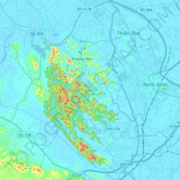
Name: Hoa Lư District topographic map, elevation, terrain.
Location: Hoa Lư District, Ninh Binh province, Vietnam (20.17239 105.87746 20.32739 105.98853)
Average elevation: 15 m
Minimum elevation: -8 m
Maximum elevation: 186 m
Other topographic maps
Click on a map to view its topography, its elevation and its terrain.
Scenic Viewpoint
Vietnam > Ninh Binh province > Hoa Lư District > Tam Cốc
Scenic Viewpoint, Thai Vi, Tam Cốc, Hoa Lư District, Ninh Bình Province, 08213, Vietnam
Average elevation: 27 m