
Sykesville topographic map
Interactive map
Click on the map to display elevation.
About this map
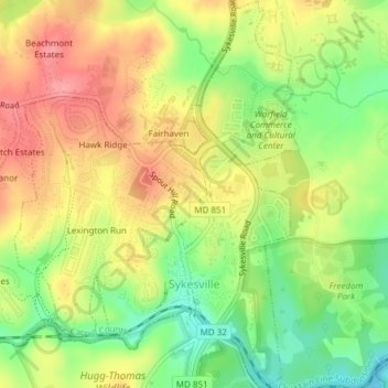
Name: Sykesville topographic map, elevation, terrain.
Location: Sykesville, Carroll County, Maryland, United States (39.35807 -76.98645 39.38733 -76.95854)
Average elevation: 152 m
Minimum elevation: 101 m
Maximum elevation: 200 m
Other topographic maps
Click on a map to view its topography, its elevation and its terrain.
Gist
United States > Maryland > Carroll County
Gist, Carroll County, Maryland, United States
Average elevation: 203 m
Kimberly Heights
United States > Maryland > Carroll County
Kimberly Heights, Carroll County, Maryland, United States
Average elevation: 209 m
Mount Airy
United States > Maryland > Carroll County
Mount Airy, Carroll County, Maryland, 21771, United States
Average elevation: 221 m
Union Bridge
United States > Maryland > Carroll County
Union Bridge, Carroll County, Maryland, United States
Average elevation: 138 m
Westminster
United States > Maryland > Carroll County
Westminster, Carroll County, Maryland, United States
Average elevation: 228 m