
Batumi topographic map
Interactive map
Click on the map to display elevation.
About this map
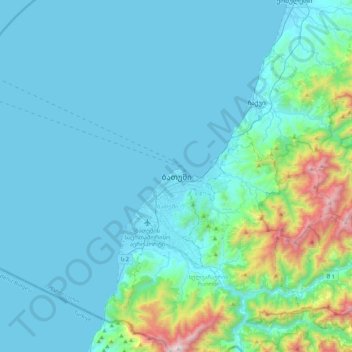
Name: Batumi topographic map, elevation, terrain.
Location: Batumi, Autonomous Republic of Adjara, 6008, Georgia (41.49095 41.47601 41.81095 41.79601)
Average elevation: 180 m
Minimum elevation: -2 m
Maximum elevation: 1,495 m
Other topographic maps
Click on a map to view its topography, its elevation and its terrain.
Batumi
Georgia > Autonomous Republic of Adjara > Batumi > Batumi
Batumi, Autonomous Republic of Adjara, Georgia
Average elevation: 121 m