
West End Common topographic map
Interactive map
Click on the map to display elevation.
About this map
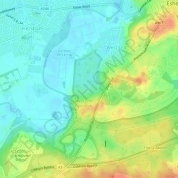
Name: West End Common topographic map, elevation, terrain.
Average elevation: 28 m
Minimum elevation: 12 m
Maximum elevation: 54 m
Other topographic maps
Click on a map to view its topography, its elevation and its terrain.
West End Common
United Kingdom > England > Surrey > Elmbridge > West End
West End Common, Stony Hill, Hersham, West End, Elmbridge, Surrey, England, KT10 9JF, United Kingdom
Average elevation: 30 m