
Thunag topographic map
Interactive map
Click on the map to display elevation.
About this map
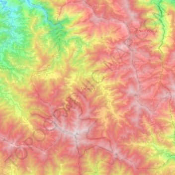
Name: Thunag topographic map, elevation, terrain.
Location: Thunag, Mandi, Himachal Pradesh, India (31.42482 77.09682 31.65806 77.33231)
Average elevation: 2,251 m
Minimum elevation: 916 m
Maximum elevation: 3,330 m
Other topographic maps
Click on a map to view its topography, its elevation and its terrain.
Shikari Devi
India > Himachal Pradesh > Thunag
Shikari Devi, Thunag, Mandi District, Himachal Pradesh, India
Average elevation: 3,003 m