
Fort Campbell topographic map
Interactive map
Click on the map to display elevation.
About this map
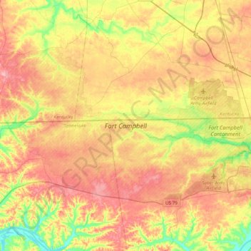
Name: Fort Campbell topographic map, elevation, terrain.
Average elevation: 170 m
Minimum elevation: 107 m
Maximum elevation: 225 m
Other topographic maps
Click on a map to view its topography, its elevation and its terrain.
Clarksville
United States > Tennessee > Montgomery County
Clarksville, Montgomery County, Middle Tennessee, Tennessee, United States
Average elevation: 155 m
Oakridge
United States > Tennessee > Montgomery County
Oakridge, Montgomery County, Middle Tennessee, Tennessee, 37142, United States
Average elevation: 194 m
Barkwood
United States > Tennessee > Montgomery County > Clarksville
Barkwood, Clarksville, Montgomery County, Middle Tennessee, Tennessee, United States
Average elevation: 157 m
Hampton Station
United States > Tennessee > Montgomery County
Hampton Station, Montgomery County, Tennessee, United States
Average elevation: 166 m
Shiloh
United States > Tennessee > Montgomery County > Shiloh
Shiloh, Montgomery County, Tennessee, 37142, United States
Average elevation: 173 m
Clarksville
United States > Tennessee > Montgomery County > Clarksville
Clarksville, Montgomery County, Tennessee, 37044, United States
Average elevation: 161 m