
Mount Joy topographic map
Interactive map
Click on the map to display elevation.
About this map
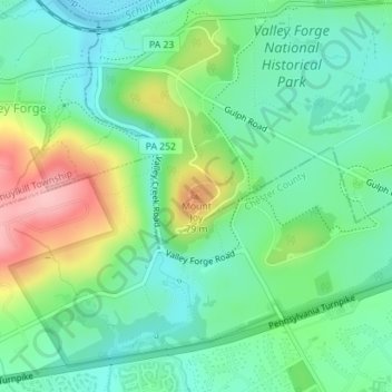
Name: Mount Joy topographic map, elevation, terrain.
Average elevation: 69 m
Minimum elevation: 22 m
Maximum elevation: 167 m
Other topographic maps
Click on a map to view its topography, its elevation and its terrain.
Belmont Terrace
United States > Pennsylvania > Montgomery County > Upper Merion Township > King of Prussia
Belmont Terrace, King of Prussia, Upper Merion Township, Montgomery County, Pennsylvania, 19406, United States
Average elevation: 45 m
King of Prussia
United States > Pennsylvania > Montgomery County > Upper Merion Township > King of Prussia
King of Prussia, Upper Merion Township, Montgomery County, Pennsylvania, 19406, United States
Average elevation: 59 m