
Bagrakote topographic map
Interactive map
Click on the map to display elevation.
About this map
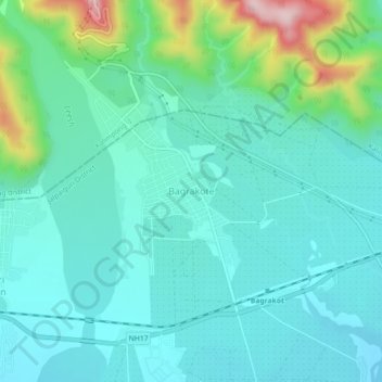
Name: Bagrakote topographic map, elevation, terrain.
Location: Bagrakote, Mal, Jalpaiguri District, West Bengal, India (26.86125 88.55674 26.90125 88.59674)
Average elevation: 212 m
Minimum elevation: 149 m
Maximum elevation: 462 m
Other topographic maps
Click on a map to view its topography, its elevation and its terrain.
Odlabari
India > West Bengal > Mal
Odlabari, Mal, Jalpaiguri District, West Bengal, 735222, India
Average elevation: 168 m
Kranti
India > West Bengal > Mal
Kranti, Mal, Jalpaiguri District, West Bengal, 735218, India
Average elevation: 100 m
Lataguri
India > West Bengal > Mal
Lataguri, Mal, Jalpaiguri District, West Bengal, 735219, India
Average elevation: 99 m
Demka Jhora
India > West Bengal > Mal > Demka Jhora
Demka Jhora, Mal, Jalpaiguri, West Bengal, India
Average elevation: 119 m