
Chandel topographic map
Interactive map
Click on the map to display elevation.
About this map
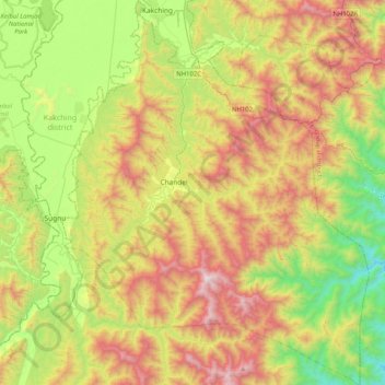
Name: Chandel topographic map, elevation, terrain.
Location: Chandel, Manipur, 795127, India (24.13407 93.88062 24.50667 94.20862)
Average elevation: 966 m
Minimum elevation: 303 m
Maximum elevation: 1,897 m
Other topographic maps
Click on a map to view its topography, its elevation and its terrain.
Senapati
India > Manipur > Senapati tehsil
Senapati, Senapati tehsil, Senapati District, Manipur, India
Average elevation: 1,321 m
Loktak Lake
India > Manipur > Bishnupur > Moirang
Loktak Lake, Moirang, Bishnupur, Manipur, India
Average elevation: 771 m
Chingmai Khullen
Chingmai Khullen, Paomata, Senapati, Manipur, India
Average elevation: 1,454 m
Nambul River
Nambul River, Imphal, Lamphelpat, Imphal West, Manipur, 795001, India
Average elevation: 779 m
Khuga Dam
India > Manipur > Churachandpur
Khuga Dam, Churachandpur, Manipur, India
Average elevation: 849 m
Ningthoukhong
India > Manipur > Ningthoukhong
Ningthoukhong, Moirang, Bishnupur, Manipur, 795126, India
Average elevation: 777 m
Imphal
India > Manipur > Lamphelpat
Imphal, Lamphelpat, Imphal West, Manipur, 795001, India
Average elevation: 861 m