
Norfolk topographic map
Interactive map
Click on the map to display elevation.
About this map
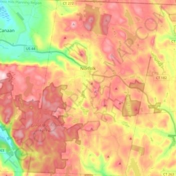
Name: Norfolk topographic map, elevation, terrain.
Average elevation: 404 m
Minimum elevation: 203 m
Maximum elevation: 559 m
According to the United States Census Bureau, the town has a total area of 46.4 square miles (120.2 km2), of which 45.3 square miles (117.4 km2) are land and 1.1 square miles (2.9 km2), or 2.38%, are water. The town is located in the Litchfield Hills portion of the Appalachian mountain range. Norfolk's elevation is 1,230 feet (370 m) above sea level, and the town is sometimes called "the Icebox of Connecticut" for its severe winters and particularly cool summers.