
Basin Mountain topographic map
Interactive map
Click on the map to display elevation.
About this map
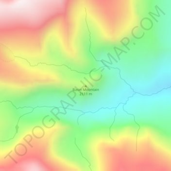
Name: Basin Mountain topographic map, elevation, terrain.
Location: Basin Mountain, Glacier County, Montana, United States (48.55103 -113.36348 48.55113 -113.36338)
Average elevation: 2,075 m
Minimum elevation: 1,702 m
Maximum elevation: 2,529 m
Other topographic maps
Click on a map to view its topography, its elevation and its terrain.
Pray Lake
United States > Montana > Glacier County
Pray Lake, Glacier County, Montana, United States
Average elevation: 1,717 m
Cut Bank
United States > Montana > Glacier County
Cut Bank, Glacier County, Montana, United States
Average elevation: 1,147 m