
Frankenmuth Township topographic map
Interactive map
Click on the map to display elevation.
About this map
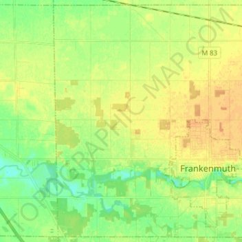
Name: Frankenmuth Township topographic map, elevation, terrain.
Average elevation: 193 m
Minimum elevation: 179 m
Maximum elevation: 204 m
Other topographic maps
Click on a map to view its topography, its elevation and its terrain.
Saginaw Charter Township
United States > Michigan > Saginaw County
Saginaw Charter Township, Saginaw County, Michigan, United States
Average elevation: 186 m
City of Frankenmuth
United States > Michigan > Saginaw County
City of Frankenmuth, Saginaw County, Michigan, United States
Average elevation: 195 m
City of Saginaw
United States > Michigan > Saginaw County
City of Saginaw, Saginaw County, Michigan, United States
Average elevation: 185 m