Geolocate

Pillar topographic map

Interactive map

Click on the map to display elevation.

About this map

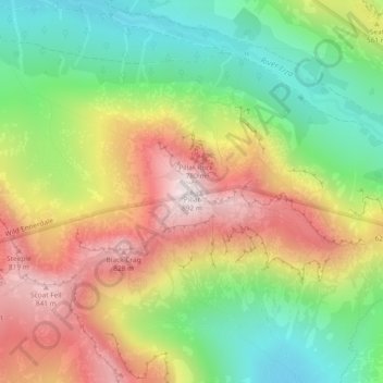
Name: Pillar topographic map, elevation, terrain.

Location: Pillar, Copeland, Cumbria, North West England, England, CA23 3AX, United Kingdom (54.49743 -3.28123 54.49753 -3.28113)

Average elevation: 486 m

Minimum elevation: 154 m

Maximum elevation: 886 m

Other topographic maps

Click on a map to view its topography, its elevation and its terrain.

Haile

United Kingdom > England > Cumbria > Copeland > Haile

Haile, Copeland, Cumbria, North West England, England, United Kingdom

Average elevation: 125 m

Blake Fell

United Kingdom > England > Cumbria > Copeland

Blake Fell, Copeland, Cumbria, North West England, England, CA13 0SU, United Kingdom

Average elevation: 381 m

Hycemoor

United Kingdom > England > Cumbria > Copeland > Bootle > Hycemoor

Hycemoor, Bootle, Copeland, Cumbria, North West England, England, LA19 5TY, United Kingdom

Average elevation: 30 m

Lamplugh

United Kingdom > England > Cumbria > Copeland > Lamplugh

Lamplugh, Copeland, Cumbria, North West England, England, United Kingdom

Average elevation: 227 m

Gosforth

United Kingdom > England > Cumbria > Copeland > Gosforth

Gosforth, Copeland, Cumbria, North West England, England, United Kingdom

Average elevation: 99 m

Hard Knott

United Kingdom > England > Cumbria > Copeland

Hard Knott, Copeland, Cumbria, North West England, England, LA20 6EQ, United Kingdom

Average elevation: 334 m