Geolocate

Hafravatn topographic map

Interactive map

Click on the map to display elevation.

About this map

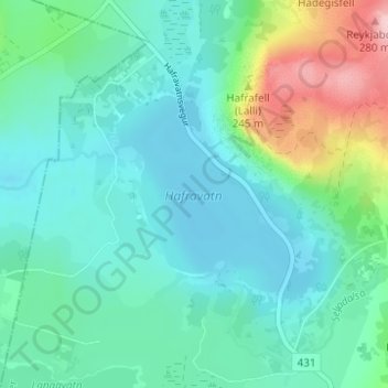
Name: Hafravatn topographic map, elevation, terrain.

Location: Hafravatn, Hafravatnsvegur, Reykjavik, Capital Region, 270, Iceland (64.12375 -21.67449 64.13753 -21.64644)

Average elevation: 109 m

Minimum elevation: 67 m

Maximum elevation: 258 m

Other topographic maps

Click on a map to view its topography, its elevation and its terrain.

Grundir

Iceland > Reykjavik

Grundir, Kjalarnes, Reykjavik, Capital Region, 116, Iceland

Average elevation: 30 m

Engey

Iceland > Reykjavik

Engey, Reykjavik, Capital Region, Iceland

Average elevation: 0 m

Reykjavik

Iceland > Reykjavik

Reykjavik, Capital Region, 121, Iceland

Average elevation: 89 m

Vesturhöfn

Iceland > Reykjavik

Vesturhöfn, Vesturbær, Reykjavik, Capital Region, Iceland

Average elevation: 4 m