
Orinoco River topographic map
Interactive map
Click on the map to display elevation.
About this map
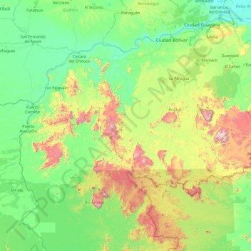
Name: Orinoco River topographic map, elevation, terrain.
Location: Orinoco River, Cedeño Municipality, Bolívar, 8051, Venezuela (2.22776 -67.86370 9.03508 -60.77389)
Average elevation: 321 m
Minimum elevation: -1 m
Maximum elevation: 2,764 m
Other topographic maps
Click on a map to view its topography, its elevation and its terrain.
Aprada Tepui
Venezuela > Bolívar > Parroquia Sección Capital Gran Sabana
Aprada Tepui, Parroquia Sección Capital Gran Sabana, Gran Sabana Municipality, Bolívar, Venezuela
Average elevation: 2,117 m
Villa Betania
Venezuela > Bolívar > Ciudad Guayana (Puerto Ordaz)
Villa Betania, Ciudad Guayana (Puerto Ordaz), Parroquia Unare, Distrito Caroní, Bolívar, Venezuela
Average elevation: 110 m