
Kicking Horse topographic map
Interactive map
Click on the map to display elevation.
About this map
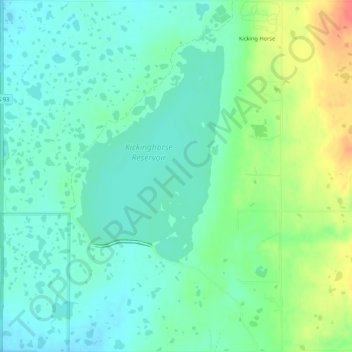
Name: Kicking Horse topographic map, elevation, terrain.
Location: Kicking Horse, Lake County, Montana, United States (47.44261 -114.09698 47.47892 -114.05407)
Average elevation: 938 m
Minimum elevation: 922 m
Maximum elevation: 973 m
Other topographic maps
Click on a map to view its topography, its elevation and its terrain.
Wild Horse Island
United States > Montana > Lake County
Wild Horse Island, Lake County, Montana, United States
Average elevation: 916 m
Flathead Lake
United States > Montana > Lake County
Flathead Lake, Lake County, Montana, United States
Average elevation: 1,168 m
Picture Lake
United States > Montana > Lake County
Picture Lake, Lake County, Montana, United States
Average elevation: 2,220 m