
Mount Scenery topographic map
Interactive map
Click on the map to display elevation.
About this map
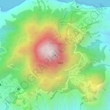
Name: Mount Scenery topographic map, elevation, terrain.
Location: Mount Scenery, Windwardside, Saba, Netherlands (17.63402 -63.23702 17.63412 -63.23692)
Average elevation: 339 m
Minimum elevation: 0 m
Maximum elevation: 847 m
Mount Scenery is an active volcano in the Caribbean Netherlands. Its lava dome forms the summit of the Saba island stratovolcano. At an elevation of 887 m (2,910 ft), it is the highest point in both the Kingdom of the Netherlands, and, since the dissolution of the Netherlands Antilles on 10 October 2010, the highest point in the Netherlands proper.