
Montiel topographic map
Interactive map
Click on the map to display elevation.
About this map
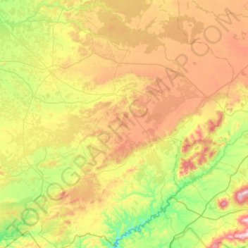
Name: Montiel topographic map, elevation, terrain.
Average elevation: 882 m
Minimum elevation: 590 m
Maximum elevation: 1,333 m
Other topographic maps
Click on a map to view its topography, its elevation and its terrain.
Carrizosa
Spain > Castile-La Mancha > Campo de Montiel > Carrizosa
Carrizosa, Campo de Montiel, Ciudad Real, Castile-La Mancha, Spain
Average elevation: 871 m