
Woqooyi Galbeed topographic map
Interactive map
Click on the map to display elevation.
About this map
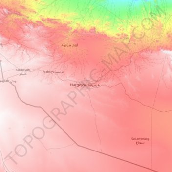
Name: Woqooyi Galbeed topographic map, elevation, terrain.
Location: Woqooyi Galbeed, Somaliland, Somalia (8.77253 43.28622 10.32074 44.89675)
Average elevation: 1,130 m
Minimum elevation: 37 m
Maximum elevation: 1,758 m
Other topographic maps
Click on a map to view its topography, its elevation and its terrain.
Biyo Cas
Somaliland > Woqooyi Galbeed > Hargeisa District
Biyo Cas, Hargeisa District, Woqooyi Galbeed, Somaliland, Somalia
Average elevation: 1,268 m
Hargeisa
Somaliland > Woqooyi Galbeed > Hargeisa District
Hargeisa, Hargeisa District, Woqooyi Galbeed, Somaliland, Somalia
Average elevation: 1,289 m
Garbis
Somaliland > Lower Shabelle > Bisiqley
Garbis, Bisiqley, Afgooye District, Lower Shabelle, 002526, Somaliland
Average elevation: 88 m
Odweine
Somaliland > Togdheer > Oodweyne District
Odweine, Oodweyne District, Togdheer, Somaliland, NC-3811-Q02-004, Somalia
Average elevation: 1,065 m