
Ramble topographic map
Interactive map
Click on the map to display elevation.
About this map
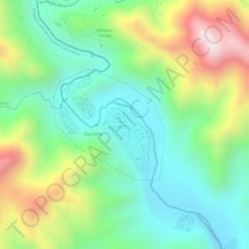
Name: Ramble topographic map, elevation, terrain.
Location: Ramble, Saint Thomas, Surrey County, Jamaica (17.97230 -76.62367 17.98436 -76.61107)
Average elevation: 374 m
Minimum elevation: 166 m
Maximum elevation: 705 m
Other topographic maps
Click on a map to view its topography, its elevation and its terrain.
Wakefield
Jamaica > Saint Thomas > Trinity Ville > Wakefield
Wakefield, Trinity Ville, Saint Thomas, Surrey County, Jamaica
Average elevation: 470 m
Lebanan
Jamaica > Saint Thomas > Lebanan
Lebanan, Rowlandsfield, Saint Thomas, Surrey County, Jamaica
Average elevation: 439 m