
Blackball topographic map
Interactive map
Click on the map to display elevation.
About this map
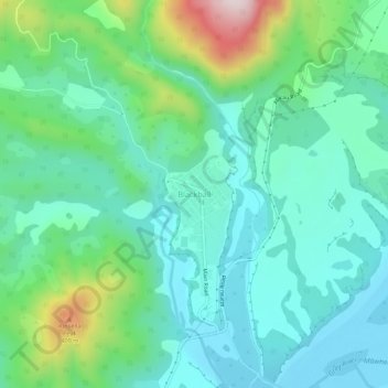
Name: Blackball topographic map, elevation, terrain.
Location: Blackball, Grey District, West Coast, 7804, New Zealand (-42.38403 171.39195 -42.34403 171.43195)
Average elevation: 147 m
Minimum elevation: 29 m
Maximum elevation: 525 m
Blackball is a small town on the West Coast of the South Island of New Zealand, approximately 29 km from Greymouth. Elevation is approximately 100 metres. The town was named after the Black Ball Shipping Line, which leased land in the area to mine for coal.
Other topographic maps
Click on a map to view its topography, its elevation and its terrain.
Greymouth
New Zealand > West Coast > Grey District
Greymouth, Grey District, West Coast, 7801, New Zealand
Average elevation: 40 m
Paddock Hill
New Zealand > West Coast > Grey District
Paddock Hill, Grey District, West Coast, New Zealand
Average elevation: 781 m