
Lake Pend Oreille topographic map
Interactive map
Click on the map to display elevation.
About this map
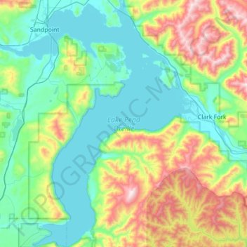
Name: Lake Pend Oreille topographic map, elevation, terrain.
Location: Lake Pend Oreille, Bonner County, Idaho, United States (47.94850 -116.62046 48.31977 -116.19322)
Average elevation: 941 m
Minimum elevation: 619 m
Maximum elevation: 1,931 m
Other topographic maps
Click on a map to view its topography, its elevation and its terrain.
Priest River
United States > Idaho > Bonner County
Priest River, Bonner County, Idaho, United States
Average elevation: 742 m
Blanchard
United States > Idaho > Bonner County
Blanchard, Bonner County, Idaho, 83804, United States
Average elevation: 718 m
Sandpoint
United States > Idaho > Bonner County
Sandpoint, Bonner County, Idaho, United States
Average elevation: 658 m
East Hope
United States > Idaho > Bonner County > East Hope
East Hope, Bonner County, Idaho, United States
Average elevation: 710 m
Clark Fork
United States > Idaho > Bonner County
Clark Fork, Bonner County, Idaho, United States
Average elevation: 681 m