
Untereggen topographic map
Interactive map
Click on the map to display elevation.
About this map
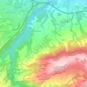
Name: Untereggen topographic map, elevation, terrain.
Location: Untereggen, Wahlkreis Rorschach, St. Gallen, 9033, Switzerland (47.44009 9.42844 47.46568 9.48331)
Average elevation: 640 m
Minimum elevation: 446 m
Maximum elevation: 928 m
Other topographic maps
Click on a map to view its topography, its elevation and its terrain.
Untereggen
Switzerland > St. Gallen > Wahlkreis Rorschach > Untereggen > Untereggen
Untereggen, Wahlkreis Rorschach, St. Gallen, 9033, Switzerland
Average elevation: 646 m
Altenrhein
Switzerland > St. Gallen > Wahlkreis Rorschach > Altenrhein
Altenrhein, Thal, Wahlkreis Rorschach, St. Gallen, 9423, Switzerland
Average elevation: 408 m
Rorschach
Switzerland > St. Gallen > Wahlkreis Rorschach
Rorschach, Wahlkreis Rorschach, St. Gallen, 9400, Switzerland
Average elevation: 452 m