
Palmyra topographic map
Interactive map
Click on the map to display elevation.
About this map
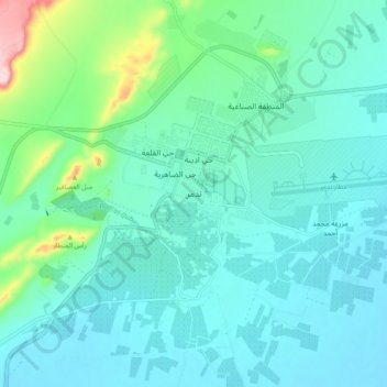
Name: Palmyra topographic map, elevation, terrain.
Average elevation: 423 m
Minimum elevation: 377 m
Maximum elevation: 644 m
With the elevation of Palmyra to a colonia around 213–216, the city ceased being subject to Roman provincial governors and taxes. Palmyra incorporated Roman institutions into its system while keeping many of its former ones. The council remained, and the strategos designated one of two annually-elected magistrates. This duumviri implemented the new colonial constitution, replacing the archons. Palmyra's political scene changed with the rise of Odaenathus and his family; an inscription dated to 251 describes Odaenathus' son Hairan I as "Ras" (lord) of Palmyra (exarch in the Greek section of the inscription) and another inscription dated to 252 describes Odaenathus with the same title. Odaenathus was probably elected by the council as exarch, which was an unusual title in the Roman empire and was not part of the traditional Palmyrene governance institutions. Whether Odaenathus' title indicated a military or a priestly position is unknown, but the military role is more likely. By 257 Odaenathus was known as a consularis, possibly the legatus of the province of Phoenice. In 258 Odaenathus began extending his political influence, taking advantage of regional instability caused by Sasanian aggression; this culminated in the Battle of Edessa, Odaenathus' royal elevation and mobilization of troops, which made Palmyra a kingdom.
Other topographic maps
Click on a map to view its topography, its elevation and its terrain.
Wa'er Neighborhood
Wa'er Neighborhood, Homs Subdistrict, Homs District, Homs Governorate, Syria
Average elevation: 489 m
Az Za`faranah
Az Za`faranah, Talbiseh Subdistrict, Al-Rastan District, Homs Governorate, Syria
Average elevation: 460 m
Ad Duwayr
Ad Duwayr, Homs Subdistrict, Homs District, Homs Governorate, Syria
Average elevation: 482 m
Kafr `Abdah
Kafr `Abdah, Al-Qusayr Subdistrict, Al-Qusayr District, Homs Governorate, Syria
Average elevation: 504 m
Homs
Homs, Homs Subdistrict, Homs District, Homs Governorate, Syria
Average elevation: 533 m
Al Hawz
Al Hawz, Al-Qusayr Subdistrict, Al-Qusayr District, Homs Governorate, Syria
Average elevation: 503 m
Qastal
Syria > Homs Governorate > Qastal
Qastal, Jubb Al-Jarah Subdistrict, Al-Mukharram District, Homs Governorate, Syria
Average elevation: 627 m
Al Qusayr
Syria > Homs Governorate > Al Qusayr
Al Qusayr, Al-Qusayr Subdistrict, Al-Qusayr District, Homs Governorate, Syria
Average elevation: 540 m
Al Burayj
Syria > Homs Governorate > Al Burayj
Al Burayj, Hisyah Subdistrict, Homs District, Homs Governorate, Syria
Average elevation: 1,121 m
Talkalakh Subistrict
Talkalakh Subistrict, Talkalakh District, Homs Governorate, Syria
Average elevation: 265 m
Al-Rastan
Al-Rastan, Al-Rastan Subdistrict, Al-Rastan District, Homs Governorate, Syria
Average elevation: 408 m
Talbisah
Talbisah, Talbiseh Subdistrict, Al-Rastan District, Homs Governorate, Syria
Average elevation: 464 m
Jamaliyah
Jamaliyah, Al-Mukharram Subdistrict, Al-Mukharram District, Homs Governorate, Syria
Average elevation: 650 m