
Hockley Heath topographic map
Interactive map
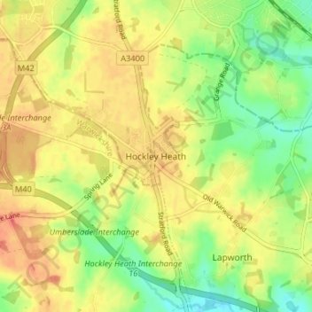
Click on the map to display elevation.
About this map
Name: Hockley Heath topographic map, elevation, terrain.
Average elevation: 134 m
Minimum elevation: 107 m
Maximum elevation: 155 m
Historically part of the parish of Hampton in Arden, the earliest reference here is to Nuthurst,situated south of the present day village. Dugdale found no mention of it before the reign of Henry III (1216–72) but it has been identified with the woodland 'aet Hnuthyrste' given with Shottery to Worcester Cathedral by Offa c. 705. Werfryd, Bishop of Worcester, in 872 granted to Eanwulf, the Kings thane, land at Hnuthyrst for four lives, with reversion to the monastery of Stratford. After the Norman Conquest the name usually appeared as Notehurst, but gradually reverted to its present and original spelling. Hockley Heath first appeared in the 13th century. It was part of Hampton-in-Arden, and 1/5 knight's fee in Nuthurst was held of Niel de Mowbray c. 1230 and of Roger de Mowbray in 1242. The overlordship descended in this family, being held by Roger de Mowbray at his death in 1297, and by John Mowbray, Duke of Norfolk, in 1432. After the Mowbrays it passed to the Montforts, Hastings and then to the Trussells and it was Sir William Trussell of Nuthurst who informed Edward II of his disposition in favour of his son. By the 18th century it had passed to the Archers of Umberslade Hall and Lord Archer raised a 70 feet (21 m) limestone block obelisk on the estate in 1749. The reason for this is unclear, possibly to celebrate his elevation to the peerage or just, as was the fashion during that period, as a folly. However, according to local folklore it is said to mark the passing of a favoured horse, which is buried beneath it.