
Horefto topographic map
Interactive map
Click on the map to display elevation.
About this map
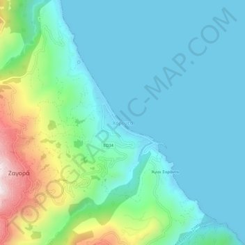
Name: Horefto topographic map, elevation, terrain.
Average elevation: 126 m
Minimum elevation: -1 m
Maximum elevation: 593 m
Other topographic maps
Click on a map to view its topography, its elevation and its terrain.
Ζαγορά
Greece > Thessaly and Central Greece > Regional Unit of Magnesia > Municipal Unit of Zagora
Ζαγορά, Municipal Unit of Zagora, Zagora - Mouresi Municipality, Regional Unit of Magnesia, Thessaly, Thessaly and Central Greece, 370 01, Greece
Average elevation: 523 m
Milina
Greece > Thessaly and Central Greece > Regional Unit of Magnesia > Sipias Municipal Unit
Milina, Sipias Municipal Unit, South Pilio Municipality, Regional Unit of Magnesia, Thessaly, Thessaly and Central Greece, 370 13, Greece
Average elevation: 81 m
Makrinitsa
Greece > Thessaly and Central Greece > Regional Unit of Magnesia > Volos Municipality
Makrinitsa, Volos Municipality, Regional Unit of Magnesia, Thessaly, Thessaly and Central Greece, 370 11, Greece
Average elevation: 663 m
Volos
Greece > Thessaly and Central Greece > Regional Unit of Magnesia > Volos
Volos, Volos Municipality, Regional Unit of Magnesia, Thessaly, Thessaly and Central Greece, 38333, Greece
Average elevation: 249 m
Volos Municipality
Greece > Thessaly and Central Greece > Regional Unit of Magnesia
Volos Municipality, Regional Unit of Magnesia, Thessaly, Thessaly and Central Greece, Greece
Average elevation: 228 m
Almyros Municipality
Greece > Thessaly and Central Greece > Regional Unit of Magnesia
Almyros Municipality, Regional Unit of Magnesia, Thessaly, Thessaly and Central Greece, Greece
Average elevation: 334 m
Stefanovikio
Greece > Thessaly and Central Greece > Regional Unit of Magnesia
Stefanovikio, Rigas Feraios Municipality, Regional Unit of Magnesia, Thessaly, Thessaly and Central Greece, 375 00, Greece
Average elevation: 53 m
Agii Saranta
Greece > Thessaly and Central Greece > Regional Unit of Magnesia > Zagora > Agii Saranta
Agii Saranta, Zagora, Zagora - Mouresi Municipality, Regional Unit of Magnesia, Thessaly, Thessaly and Central Greece, 37001, Greece
Average elevation: 114 m