
Savage topographic map
Interactive map
Click on the map to display elevation.
About this map
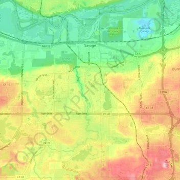
Name: Savage topographic map, elevation, terrain.
Location: Savage, Scott County, Minnesota, 55378, United States (44.71619 -93.39905 44.79863 -93.32848)
Average elevation: 262 m
Minimum elevation: 186 m
Maximum elevation: 357 m
Other topographic maps
Click on a map to view its topography, its elevation and its terrain.
Eagle Creek
United States > Minnesota > Scott County
Eagle Creek, Scott County, Minnesota, United States
Average elevation: 284 m
Shakopee
United States > Minnesota > Scott County > Shakopee > Shakopee
Shakopee, Scott County, Minnesota, 55379, United States
Average elevation: 248 m
Savage
United States > Minnesota > Scott County > Savage > Savage
Savage, Scott County, Minnesota, 55378, United States
Average elevation: 251 m
Shakopee
United States > Minnesota > Scott County
Shakopee, Scott County, Minnesota, 55379, United States
Average elevation: 257 m
Prior Lake
United States > Minnesota > Scott County
Prior Lake, Scott County, Minnesota, 55372, United States
Average elevation: 282 m