
Cahora Bassa topographic map
Interactive map
Click on the map to display elevation.
About this map
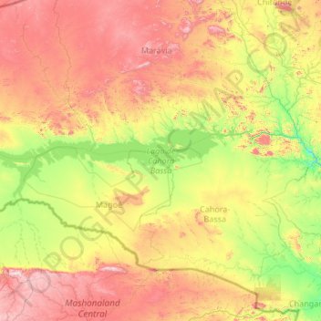
Name: Cahora Bassa topographic map, elevation, terrain.
Location: Cahora Bassa, Tete, Mozambique (-15.97580 30.65788 -15.49773 32.71577)
Average elevation: 595 m
Minimum elevation: 163 m
Maximum elevation: 1,559 m
Other topographic maps
Click on a map to view its topography, its elevation and its terrain.