
Torry topographic map
Interactive map
Click on the map to display elevation.
About this map
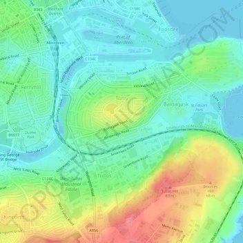
Name: Torry topographic map, elevation, terrain.
Location: Torry, Aberdeen City, Scotland, United Kingdom (57.11918 -2.09982 57.14531 -2.04441)
Average elevation: 27 m
Minimum elevation: -4 m
Maximum elevation: 83 m
Other topographic maps
Click on a map to view its topography, its elevation and its terrain.
Northfield
United Kingdom > Scotland > Aberdeen City
Northfield, Aberdeen City, Scotland, United Kingdom
Average elevation: 91 m
Brimmond Hill
United Kingdom > Scotland > Aberdeen City
Brimmond Hill, Aberdeen City, Scotland, AB15 8SJ, United Kingdom
Average elevation: 165 m
Peterculter
United Kingdom > Scotland > Aberdeen City
Peterculter, Aberdeen City, Scotland, AB14 0SG, United Kingdom
Average elevation: 61 m
Kingswells
United Kingdom > Scotland > Aberdeen City
Kingswells, Aberdeen City, Scotland, United Kingdom
Average elevation: 151 m
Bridge of Don
United Kingdom > Scotland > Aberdeen City
Bridge of Don, Aberdeen City, Scotland, United Kingdom
Average elevation: 47 m