
Roswell topographic map
Interactive map
Click on the map to display elevation.
About this map
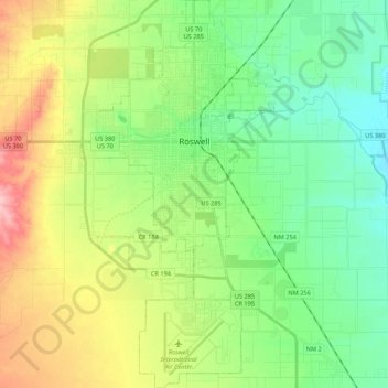
Name: Roswell topographic map, elevation, terrain.
Location: Roswell, Chaves County, New Mexico, United States (33.28010 -104.58627 33.45973 -104.47536)
Average elevation: 1,106 m
Minimum elevation: 1,057 m
Maximum elevation: 1,199 m
Other topographic maps
Click on a map to view its topography, its elevation and its terrain.
Roswell
United States > New Mexico > Chaves County > Roswell
Roswell, Chaves County, New Mexico, 88201, United States
Average elevation: 1,126 m
Midway
United States > New Mexico > Chaves County
Midway, Chaves County, New Mexico, United States
Average elevation: 1,089 m