
Cornwall topographic map
Interactive map
Click on the map to display elevation.
About this map
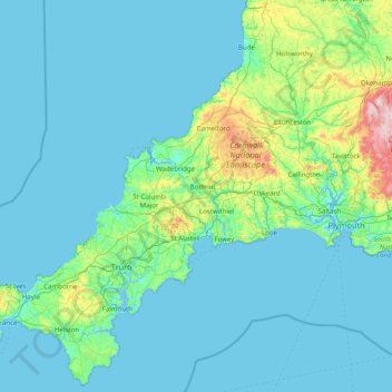
Name: Cornwall topographic map, elevation, terrain.
Location: Cornwall, England, United Kingdom (49.95541 -5.74711 50.93127 -4.16494)
Average elevation: 55 m
Minimum elevation: 0 m
Maximum elevation: 614 m
The interior of the county consists of a roughly east–west spine of infertile and exposed upland, with a series of granite intrusions, such as Bodmin Moor, which contains the highest land within Cornwall. From east to west, and with approximately descending altitude, these are Bodmin Moor, Hensbarrow north of St Austell, Carnmenellis to the south of Camborne, and the Penwith or Land's End peninsula. These intrusions are the central part of the granite outcrops that form the exposed parts of the Cornubian batholith of south-west Britain, which also includes Dartmoor to the east in Devon and the Isles of Scilly to the west, the latter now being partially submerged.
Other topographic maps
Click on a map to view its topography, its elevation and its terrain.
London
United Kingdom > England > London
London, Greater London, England, SW1A 2DX, United Kingdom
Average elevation: 42 m
London
London, Greater London, England, United Kingdom
Average elevation: 66 m
Bristol
United Kingdom > England > City of Bristol
Bristol, City of Bristol, West of England, England, United Kingdom
Average elevation: 55 m
Winchester
United Kingdom > England > Hampshire
Winchester, Hampshire, England, United Kingdom
Average elevation: 73 m
Greater Manchester
Greater Manchester, England, United Kingdom
Average elevation: 141 m
Skipton
United Kingdom > England > Skipton
Skipton, North Yorkshire, Yorkshire and the Humber, England, BD23 1DU, United Kingdom
Average elevation: 201 m
Sheffield
Sheffield, South Yorkshire, England, United Kingdom
Average elevation: 168 m
Hull
United Kingdom > England > Kingston upon Hull
Hull, Kingston upon Hull, England, HU1 3RJ, United Kingdom
Average elevation: 21 m
East of England
East of England, England, United Kingdom
Average elevation: 39 m
Dorset
United Kingdom > England > Talbot Village
Dorset, Alder Road, Branksome, Talbot Village, Bournemouth, Christchurch and Poole, South West England, England, BH12 5BJ, United Kingdom
Average elevation: 57 m
Oxford
United Kingdom > England > Oxfordshire
Oxford, Oxfordshire, England, United Kingdom
Average elevation: 81 m
East Riding of Yorkshire
East Riding of Yorkshire, England, United Kingdom
Average elevation: 30 m
Hastings
United Kingdom > England > East Sussex
Hastings, East Sussex, England, United Kingdom
Average elevation: 36 m
Liverpool
Liverpool, Liverpool City Region, England, United Kingdom
Average elevation: 26 m
Torquay
United Kingdom > England > Torbay
Torquay, Torbay, England, TQ1 1TR, United Kingdom
Average elevation: 31 m
Lake District National Park
Lake District National Park, England, United Kingdom
Average elevation: 206 m
Bath
United Kingdom > England > Bath and North East Somerset
Bath, Bath and North East Somerset, West of England, England, United Kingdom
Average elevation: 100 m
Stroud
United Kingdom > England > Gloucestershire
Stroud, Gloucestershire, England, United Kingdom
Average elevation: 113 m
Kent
United Kingdom > England > Sevenoaks
Kent, Beechenlea Lane, Swanley, Sevenoaks, Kent, South East, England, BR8 7PR, United Kingdom
Average elevation: 37 m
North Norfolk
United Kingdom > England > Norfolk
North Norfolk, Norfolk, England, United Kingdom
Average elevation: 26 m
Warminster
United Kingdom > England > Wiltshire
Warminster, Wiltshire, England, United Kingdom
Average elevation: 143 m
City of London
United Kingdom > England > City of London > City of London
City of London, England, EC2V 5AE, United Kingdom
Average elevation: 42 m
North Yorkshire
North Yorkshire, Yorkshire and the Humber, England, United Kingdom
Average elevation: 153 m
Somerset
Somerset, South West England, England, United Kingdom
Average elevation: 87 m
Norwich
United Kingdom > England > Norfolk
Norwich, Norfolk, England, United Kingdom
Average elevation: 28 m
Coventry
Coventry, West Midlands Combined Authority, England, United Kingdom
Average elevation: 99 m
Plymouth
United Kingdom > England > Devon > Plymouth
Plymouth, Devon, South West England, England, PL1 1HH, United Kingdom
Average elevation: 81 m
Nottingham
United Kingdom > England > Nottinghamshire
Nottingham, England, United Kingdom
Average elevation: 56 m
Peterborough
United Kingdom > England > City of Peterborough
Peterborough, City of Peterborough, Cambridgeshire and Peterborough, England, PE1 1XH, United Kingdom
Average elevation: 17 m
Sharpness
United Kingdom > England > Gloucestershire > Stroud
Sharpness, Stroud, Gloucestershire, England, GL13 9PE, United Kingdom
Average elevation: 17 m
Skirpenbeck
United Kingdom > England > East Riding of Yorkshire
Skirpenbeck, East Riding of Yorkshire, England, United Kingdom
Average elevation: 28 m
Dartmoor National Park
United Kingdom > England > Devon
Dartmoor National Park, Devon, England, United Kingdom
Average elevation: 239 m
Hampshire
Hampshire, South East, England, United Kingdom
Average elevation: 73 m
Holmfirth
United Kingdom > England > Kirklees
Holmfirth, Kirklees, West Yorkshire, England, HD9 7DE, United Kingdom
Average elevation: 260 m
Bradford
Bradford, West Yorkshire, England, United Kingdom
Average elevation: 175 m
Doncaster
Doncaster, South Yorkshire, England, United Kingdom
Average elevation: 31 m
Brighton
United Kingdom > England > Brighton and Hove
Brighton, Brighton and Hove, England, United Kingdom
Average elevation: 64 m
Durham
United Kingdom > England > County Durham
Durham, County Durham, North East, England, DH1 3NG, United Kingdom
Average elevation: 119 m
Hampstead Heath
United Kingdom > England > London
Hampstead Heath, Gospel Oak, London Borough of Camden, London, Greater London, England, United Kingdom
Average elevation: 94 m