
Okuma topographic map
Interactive map
Click on the map to display elevation.
About this map
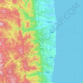
Name: Okuma topographic map, elevation, terrain.
Location: Okuma, Futaba County, Fukushima Prefecture, Japan (37.37208 140.85370 37.45020 141.29444)
Average elevation: 224 m
Minimum elevation: -1 m
Maximum elevation: 870 m
Other topographic maps
Click on a map to view its topography, its elevation and its terrain.
Naraha
Naraha, Futaba County, Fukushima Prefecture, Japan
Average elevation: 183 m
みるーる天神
Japan > Futaba County > Naraha
みるーる天神, 広野小高線旧道, Maebara, Naraha, Futaba County, Fukushima Prefecture, 979-0513, Japan
Average elevation: 9 m
Kawauchi
Japan > Futaba County > Kawauchi
Kawauchi, Futaba County, Fukushima Prefecture, Japan
Average elevation: 574 m