
Make a donation
Gear up for your next adventure:
As an Amazon Associate, this site earns from qualifying purchases at no extra cost to you.
Xenia topographic map
Click on the map to display elevation.
Make a donation
Gear up for your next adventure:
As an Amazon Associate, this site earns from qualifying purchases at no extra cost to you.
About this map
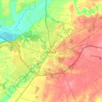
Name: Xenia topographic map, elevation, terrain.
Location: Xenia, Greene County, Ohio, 45385, United States (39.64920 -83.99302 39.72258 -83.86106)
Average elevation: 288 m
Minimum elevation: 239 m
Maximum elevation: 328 m
Make a donation
Gear up for your next adventure:
As an Amazon Associate, this site earns from qualifying purchases at no extra cost to you.
Other topographic maps
Click on a map to view its topography, its elevation and its terrain.
John Bryan State Park
United States > Ohio > Greene County > Yellow Springs > Clifton
Average elevation: 309 m
Make a donation
Gear up for your next adventure:
As an Amazon Associate, this site earns from qualifying purchases at no extra cost to you.