
Lakhimpur topographic map
Interactive map
Click on the map to display elevation.
About this map
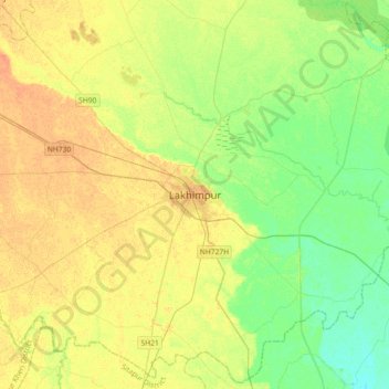
Name: Lakhimpur topographic map, elevation, terrain.
Location: Lakhimpur, Kheri, Uttar Pradesh, 262701, India (27.78631 80.62152 28.10631 80.94152)
Average elevation: 141 m
Minimum elevation: 126 m
Maximum elevation: 155 m
Lakhimpur is located at 27°57′N 80°46′E / 27.95°N 80.77°E / 27.95; 80.77. It has an average elevation of 147 metres (482 ft).
Other topographic maps
Click on a map to view its topography, its elevation and its terrain.
Kheri
India > Uttar Pradesh > Lakhimpur
Kheri, Lakhimpur, Kheri, Uttar Pradesh, 262700, India
Average elevation: 144 m